Contribute to the greening and bike & ped friendliness of our neighbor to the north, El Cerrito!
Please join City Staff THIS Wednesday, October 22nd at 7 pm in the El Cerrito City Hall Council Chambers for a Joint Study Session of the Parks & Recreation Commission and the Environmental Quality Committee and hear an update from the Community Development Department on the City’s Urban Greening Plan, currently underway. The two bodies called for the City’s successful application for a Proposition 84 Urban Greening Planning Grant in 2011. The Plan evaluates existing parks and open spaces in the city and proposes policies, programs and projects to create and enhance vibrant, ecological green spaces in El Cerrito. The public will have an opportunity to provide comments at the end of the presentation.
Additional comments and questions may be submitted to Emily Alter via email at EAlter@ci.el-cerrito.ca.us or at (510) 215-4385. The City anticipates that the draft Urban Greening Plan will be released early 2015. For more information on the Plan, please visit www.ElCerritoUrbanGreening.org
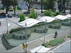
Here are some of the 96 BikeLink lockers at nearby El Cerrito Plaza BART
Come help our neighbor to the North, El Cerrito, shape its bicycle and pedestrian future!
The Open House for El Cerrito’s Active Transportation Plan will begin with a short presentation about the planning process and proposed bicycle and pedestrian networks. Focus area project posters will be available for review and comment throughout the workshop.
The City released the draft Plan for public comment on Sunday, June 14th. The Plan, which is an update to the 2007 Circulation Plan for Bicyclists and Pedestrians, evaluated the existing bicycle and pedestrian networks and identified new focus projects and programs to close gaps in these networks and provide amenities to make it easier to bike and walk in El Cerrito.
The draft Plan proposes nine focus area projects, revised bicycle and pedestrian networks, a policy toolkit and program framework to making walking and biking easier in El Cerrito. The nine focus area projects are:
- BART to Bay Trail Access Improvements at Central Avenue, Carlson Boulevard, and Cerrito Creek Connections between Plaza BART and the Bay Trail
- Ohlone Greenway Crossing Improvements – Citywide
- Citywide Wayfinding at Key Walking and Biking Routes
- Arlington Boulevard Pedestrian Improvements
- East Side Bicycle Boulevard – Blake Street, Norvell Street, Schmidt Lane, Richmond Street,
- Moeser Lane, Norvell Street, Lincoln Avenue, Albemarle Street, Behrens Street
- Wayfinding associated with East Side Bicycle Boulevard
- Key Boulevard Improvements – between Humboldt Street and Hill Street
- Fairmount Avenue Improvements – between Carlson Boulevard and Colusa Avenue
- Potrero Avenue Improvements – between western City Limit and Ohlone Greenway
 The draft Plan is available for review via the project website, www.el-cerrito.org/ATP. Public comments will be accepted from Sunday, June 14th until Friday, July 17th and may be submitted via email to the Public Works Department at streets@ci.el-cerrito.ca.us, via mail to City of El Cerrito, 10890 San Pablo Avenue, El Cerrito, CA 94530 or dropped off at the El Cerrito City Hall Front Counter, Attn: Public Works.

Give your input to improve the Greenway by El Cerrito BART stations!
Come help our neighbor to the North, El Cerrito, shape its (and your) bicycle and pedestrian future!
The primary goals of this project are to:
*Improve bicycle and pedestrian routes to transit, commercial nodes and housing
*Bring new vibrancy to the areas around the BART stations
*Increase safety and accessibility for BART riders and Greenway users
*Improve the integration of the El Cerrito Plaza and El Cerrito del Norte BART Stations with the surrounding community.
Here are some of the 96 BikeLink lockers at nearby El Cerrito Plaza BART
On Tuesday November 10 the City of El Cerrito will host a community meeting to review the preferred plan for the Ohlone Greenway at the El Cerrito del Norte and El Cerrito Plaza BART station areas. This is the last of several outreach efforts to engage the public in the process of re-designing the Ohlone Greenway at two key areas in the City. At the meeting, community members will have a chance to voice their opinion on the preferred plan to create gateway elements and outdoor gathering spaces around the Greenway and BART stations, improve the mixed-use bicycle and pedestrian path and intersection crossings, and other enhancements.For more info, go here.
Do you or your family ride, walk, roll, scoot or skate on the Ohlone Greenway? I’m sure you do, as the multi-use path on the Greenway is Albany’s Active Transportation Highway – over 1,000 trips per day on regular days when last counted several years ago!
The Parks & Rec Department is overseeing Greenway improvements so now’s the time to give input in order to have a better experience to stroll, roll or just hang out!
The information with the Project Plans and what was discussed at previous meetings is at this link:

Do you or your family ride on the Ohlone Greenway? Now’s the time to give input to improve it!
A parcourse, wayfinding, art – all can have a positive effect on the experience, safety and atmosphere of strolling and rolling.
An orchard is proposed for the eastern edge of the Greenway. What a great idea… BUT if those trees are planted too close to the multi-use path, as was already done south of Dartmouth, they will drop debris on the path, encroach on the path itself and also invite more conflicts between people biking northbound & walking on the east dg path and people who are picking fruit.
Another point someone brought up was that some of the existing trees west of the path cast are planted directly between the overhead light and the path, casting shadows on the path and making the nighttime path experience more dangerous.
In short, as Albany’s Active Transportation Highway, the City must take care not to degrade this important function. If amenities to either side are to be added, it should be done with great care.
Please attend this meeting to give your input and improve the Ohlone Greenway for everyone – strollers, rollers, sitters, dog-walkers, and fruit-pickers!
Full P&R agenda is at http://www.albanyca.org/index.aspx?page=16&recordid=12040
6-1: Ohlone Greenway Design: Restoration Design Group will give a presentation.
Recommended Actions:
1. That the Commission recommend a preferred concept direction to move into the design into the next phase.
2. That the Commission approve the planting of fruit and nut trees by the California Rare Fruit Growers along the eastern strip of the Ohlone Greenway as described in the Memo.
3. That the Commission set a Special Meeting Date for the 4th week of February to review the 35% Plans for the Ohlone Greenway.
Do you or your family ride, walk, roll, scoot or skate on the Ohlone Greenway? I’m sure you do, as the multi-use path on the Greenway is Albany’s Active Transportation Highway – over 1,000 trips per day on regular days when last counted several years ago!
The City Council is considering Greenway improvements so now’s the time to give input in order to have a better experience to stroll, roll or just hang out!
The agenda for the meeting is at this link, item 9-2.
The Consultants’ “Preferred Master Plan” is here – (fyi, you can just open it up or download the 4.8MB pdf document.)
Do you or your family ride on the Ohlone Greenway? Now’s the time to give input to improve it!
A parcourse, wayfinding, art – all can have a positive effect on the experience, safety and atmosphere of strolling and rolling.
An orchard is proposed for the eastern edge of the Greenway. What a great idea… BUT if those trees are planted too close to the multi-use path, as was already done south of Dartmouth, they will drop debris on the path, encroach on the path itself and also invite more conflicts between people biking northbound & walking on the east dg path and people who are picking fruit.
Another point someone brought up was that some of the existing trees west of the path cast are planted directly between the overhead light and the path, casting shadows on the path and making the nighttime path experience more dangerous.
In short, as Albany’s Active Transportation Highway, the City must take care not to degrade this important function. If amenities to either side are to be added, it should be done with great care.
Please attend this meeting to give your input and improve the Ohlone Greenway for everyone – strollers, rollers, sitters, dog-walkers, and fruit-pickers!
Do you or your family ride, walk, roll, scoot or skate on the Ohlone Greenway? I’m sure you do, as the multi-use path on the Greenway is Albany’s Active Transportation Highway – over 1,000 trips per day on regular days when last counted several years ago!
The Parks & Rec Department is overseeing Greenway improvements so now’s the time to give input in order to have a better experience to stroll, roll or just hang out!
Do you or your family ride on the Ohlone Greenway? Now’s the time to give input to improve it!
The information with the Project Plans and what was discussed at previous meetings is at this link. However, the proposal will be updated based on feedback that they received at February 1, so people should come to see how it evolved!
At this meeting the consultants will have 35% designs for you to see and provide input. This is a crucial time in the planning process!
Preferred Concept plan that was presented to Council on February 1 included:
- Plaza area as presented in the 250K Focused amenities (Adventure play with climbing wall, fitness pod with 3 stations, both diagonal ramps, social path short cut to Solano
- Redwood Grove informal play area
- San Gabriel sculpture play
- Social paths
- 3 Creek paintings
- 3 fitness stations along Greenway with 2 pieces of equipment at each
- Dartmouth Circle improvements
- Orchards
- Public Art locations
A parcourse, wayfinding, art – all can have a positive effect on the experience, safety and atmosphere of strolling and rolling.
An orchard is proposed for the eastern edge of the Greenway. What a great idea… BUT if those trees are planted too close to the multi-use path, as was already done south of Dartmouth, they will drop debris on the path, encroach on the path itself and also invite more conflicts between people biking northbound & walking on the east dg path and people who are picking fruit.
Another point someone brought up was that some of the existing trees west of the path cast are planted directly between the overhead light and the path, casting shadows on the path and making the nighttime path experience more dangerous.
In short, as Albany’s Active Transportation Highway, the City must take care not to degrade this important function. If amenities to either side are to be added, it should be done with great care.
Please attend this meeting to give your input and improve the Ohlone Greenway for everyone – strollers, rollers, sitters, dog-walkers, and fruit-pickers!
**THE AGENDA AND 35% PLANS ARE HERE** (NOTE: 4.3 MB FILE)
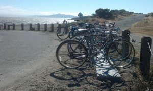
These racks that AS&R funded at the Waterfront are perfectly situated for folks who want to enjoy the beach, a hike or just enjoy the beautiful view.
Help keep our access there!
Do you ride your bike, walk, hike, jog or otherwise enjoy the Albany Bulb & Neck areas? Do you want to continue to have access so you can enjoy the Albany Waterfront to its fullest? Both pieces are scheduled to be transferred to the East Bay Regional Park District and some groups and individuals want to curtail recreational use and bicycle access.
The City is completing its “Albany Neck & Bulb Transition Improvement Plan” public process so this meeting is your final opportunity to give your input in order to ensure that the Waterfront area is something that can be enjoyed by all.
Representatives from Albany Strollers & Rollers and Bicycle Trails Council of the East Bay were invited to a Stakeholder meeting with Albany City Staff and the Planning & Design Consultants, and we were able to voice our opinions.
BUT it is crucial that City Staff, Consultants and City Council hear from YOU AND YOUR FAMILY TO SET FORTH PRIORITIES and a plan to communicate to EBRPD.
Want to ride along our beautiful Bay? Speak up!
Bike & hiking paths? Bathrooms? Bike racks? Picnic tables? Improved bicycle access from all directions?
What would make this a great recreational area, like the areas that Berkeley has in its Marina?
This City Council meeting is the FINAL PUBLIC FORUM TO SAY THAT YES, RECREATIONAL ACCESS IS IMPORTANT TO YOU AND YOUR FAMILY!
Consultants from WRT will give a brief presentation on the process and the final study, and there will be an opportunity for public comment.
More details will be posted as we have more information but please save the date to make sure we keep access to OUR WATERFRONT!
We risk losing access to our Bay if we don’t speak up!
Written comments can be provided in advance of the meeting to cityhall@albanyca.org. We encourage written comments be sent before the day of the meeting to ensure they can be taken into consideration.
Documents related to this effort are included here:
1. Final Albany Neck & Bulb Transition Study (very large – 143 pages)
2. Conservancy Staff Report 05-29-2014
3. WRT_Albany Neck & Bulb Stakeholder Meeting_Access and Recreation
4. Scope of Consultant Services for Albany Neck and Bulb Transition Plan
5. WRT Transition Improvement Plan as of April 2015
Help ensure that Albany’s segment of the Bay Trail will be completed, and safe & fun for all!
After a group of Albany residents, including fellow Strollers & Rollers, pointed out improvements that should be made to our Waterfront, there will be a chance to see the plans and give input on the Albany Bay Trail and beach project, officially known as the Albany Beach Restoration and Public Access Project.
Let’s make sure that OUR Waterfront is optimized for people who want to bike, walk, stroll and roll. There is a lot of car parking, but not nearly as much attention paid to parking for bicycles.
Note: a quorum of the City Council and/or an advisory body to the City Council may be present at this public meeting.
Here is the site plan
And the existing conditions map
And the complete packet from the most recent public meeting (April 17), which was at the San Francisco Bay Conservation and Development Commission Design Review Board. This packet has cross-sections and more detailed plans and a staff report.
Albany resident and landscape architect Hugo Larman drafted this updated plan based on community input, which expands the beach area, adds bike racks and moves car parking near existing parking.
EIR and other info from EBRPD (scroll down to where is says “Albany Beach Habitat Restoration and Public Access Project.”)
These racks that AS&R bought are perfectly situated for folks who want to enjoy the beach, a hike or just enjoy the beautiful view, but they are lonely! We need more “there” at the Waterfront, and more bike racks near other destinations.
AS&R member Dan Johnson prepared comments and alternative plans . After further discussion, Dan & others believe that the location for parking might not be feasible. However his diagram about the amount of paving is relevant.
While not a part of EBRPD’s plan, the Albany Waterfront Committee’s Cove Enhancement Plan should be completed by the City of Albany and taken into account by EBRPD for a comprehensive plan at the entire waterfront. The only reason it was not completed in 2012 was because EBRPD requested the City hold off because of upcoming construction. That reason is long past.
In response to recent community comments, the designers are making efforts to reduce the large amount of pavement for the vehicle driveway and turnaround to leave more open space for recreation at the south end of the site. However, a number of us believe that it would be more functional and would preserve more open space (as well as reduce bicycle-pedestrian conflicts) to locate the parking near the existing parking, on the north side of Buchanan St., which would eliminate the need for the long driveway. However, this area is City-owned and outside the EBRPD project area.
(photo credit – BikeEastBay)
Share your vision for the corridor and get organized for kicking off advocacy.
Elevation 66
El Cerrito, CA 94530
(This event is organized and hosted by BikeEastBay who request you RSVP.)
This meeting is at a perfect time for you to attend and then head to AS&R’s Meeting at 7:30!
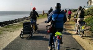
Do you bike or walk on Central Avenue under I-80 to reach the places you enjoy?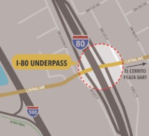
Would you like to help make it easier and safer to do so?
The Central Avenue / Interstate 80 (I-80) underpass in Richmond leads to a lot of great places—the San Francisco Bay Trail, Point Isabel Dog Park, Costco and the Richmond Marina, to name a few.
CalTrans District 4 wants your ideas on how to transform the underpass into a high-quality pedestrian and bicycle connection!

Current Underpass
Help improve your biking and walking experience in the East Bay!
Join us at the Community Workshop to share ideas on the project design. We will discuss safety features, lighting, wayfinding and other design elements.

It could look like this!!
WHO:
You! Residents, cyclists and walkers in Richmond, El Cerrito, Albany (Pierce Street and West Albany residents, that means you!!) and beyond.
For more information, go to http://www.dot.ca.gov/d4/transplanning/i-80central.html