This is a special meeting of the City Council to make the major approvals for the project, including the EIR. AS&R is awaits posting of the EIR for this meeting, as the last EIR presented by the city had language that seemed to indicate that environmental mitigations, such as bicycle connections to the community-wide bicycle network, might not be undertaken if deemed “infeasible”.
Albany has a chunk of change to spend on improving creek access and quality. And it has to start spending it within a year or two to avoid substantial financial complications (its bond money from a measure passed in the 90’s, and the duration is running out). So the City has scheduled a public discussion at City Hall starting regarding which project(s) to pursue.
There are a couple that would improve active transportation: 1) path from Tenth to Eighth Street along Codornices Creek and 2) a bridge across Cerrito Creek at Adams. The potential project at Codornices Creek would close the last gap on the Codornices Creek path from San Pablo to the soccer fields west of Fifth Street (the path from San Pablo to Tenth is about to be built as part of the senior housing under construction there).
Help connect Adams Street in Albany…
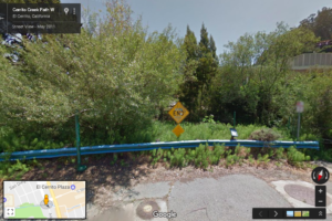
The potential project at Cerrito Creek would allow people to walk east-west along Cerrito Creek from San Pablo to Pierce. Among other, this would benefit Albany High School students living on Pierce that currently ford the creek at Adams.
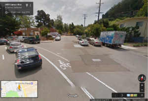
…with Carlson Blvd in El Cerrito and Richmond!
Amazingly, it would also remove the only barrier along a regional north-south cycling route stretching from near downtown Richmond to the West Oakland BART station and beyond. Most of the other cities along this route (Oakland, Emeryville, Berkeley, El Cerrito, and Richmond) have completed their segments and the only other city (Richmond) has completed a large portion of it contiguous with El Cerrito and approved a plan to complete the rest. In contrast, Albany has completed almost none of its segment.
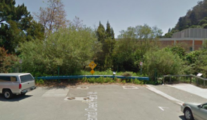
Bridge the gap!
Consequently Albany is the only gap along the existing nine mile long route and the soon to be 12 mile long route. A bridge over Cerrito Creek between Adams and Carlson would literally bridge that gap.
If either of these active transportation projects, or other aspects of creeks is of interest to you, please attend the meeting to learn more and provide your input. Thanks.
Help ensure that Albany’s segment of the Bay Trail will be completed, and safe & fun for all!
After a group of Albany residents, including fellow Strollers & Rollers, pointed out improvements that should be made to our Waterfront, there will be a chance to see the plans and give input on the Albany Bay Trail and beach project, officially known as the Albany Beach Restoration and Public Access Project.
Let’s make sure that OUR Waterfront is optimized for people who want to bike, walk, stroll and roll. There is a lot of car parking, but not nearly as much attention paid to parking for bicycles.
Note: a quorum of the City Council and/or an advisory body to the City Council may be present at this public meeting.
Here is the site plan
And the existing conditions map
And the complete packet from the most recent public meeting (April 17), which was at the San Francisco Bay Conservation and Development Commission Design Review Board. This packet has cross-sections and more detailed plans and a staff report.
Albany resident and landscape architect Hugo Larman drafted this updated plan based on community input, which expands the beach area, adds bike racks and moves car parking near existing parking.
EIR and other info from EBRPD (scroll down to where is says “Albany Beach Habitat Restoration and Public Access Project.”)
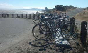
These racks that AS&R bought are perfectly situated for folks who want to enjoy the beach, a hike or just enjoy the beautiful view, but they are lonely! We need more “there” at the Waterfront, and more bike racks near other destinations.
AS&R member Dan Johnson prepared comments and alternative plans . After further discussion, Dan & others believe that the location for parking might not be feasible. However his diagram about the amount of paving is relevant.
While not a part of EBRPD’s plan, the Albany Waterfront Committee’s Cove Enhancement Plan should be completed by the City of Albany and taken into account by EBRPD for a comprehensive plan at the entire waterfront. The only reason it was not completed in 2012 was because EBRPD requested the City hold off because of upcoming construction. That reason is long past.
In response to recent community comments, the designers are making efforts to reduce the large amount of pavement for the vehicle driveway and turnaround to leave more open space for recreation at the south end of the site. However, a number of us believe that it would be more functional and would preserve more open space (as well as reduce bicycle-pedestrian conflicts) to locate the parking near the existing parking, on the north side of Buchanan St., which would eliminate the need for the long driveway. However, this area is City-owned and outside the EBRPD project area.
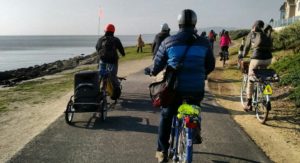
Do you or your family ride on the Ohlone Greenway? Attend this meeting to work on making it safer for all.
Albany Community Action member Céline Wallace set up a meeting with 2 police departments hosted by Albany’s Mayor and Vice Mayor about safety on the Greenway. Céline organized this after her husband was held up at gunpoint on the greenway a few weeks ago, but before a Greenway shooting/murder took place in late April.
Representatives from the Albany and El Cerrito Police Departments will be on hand to provide information on crime trends and strategies affecting safe travel on the Ohlone Greenway.