These racks that AS&R provided for the City are perfectly situated for folks who want to enjoy the beach, a hike or just enjoy the beautiful view. Let’s make sure we still have recreational access to the Albany Bulb and the Neck!
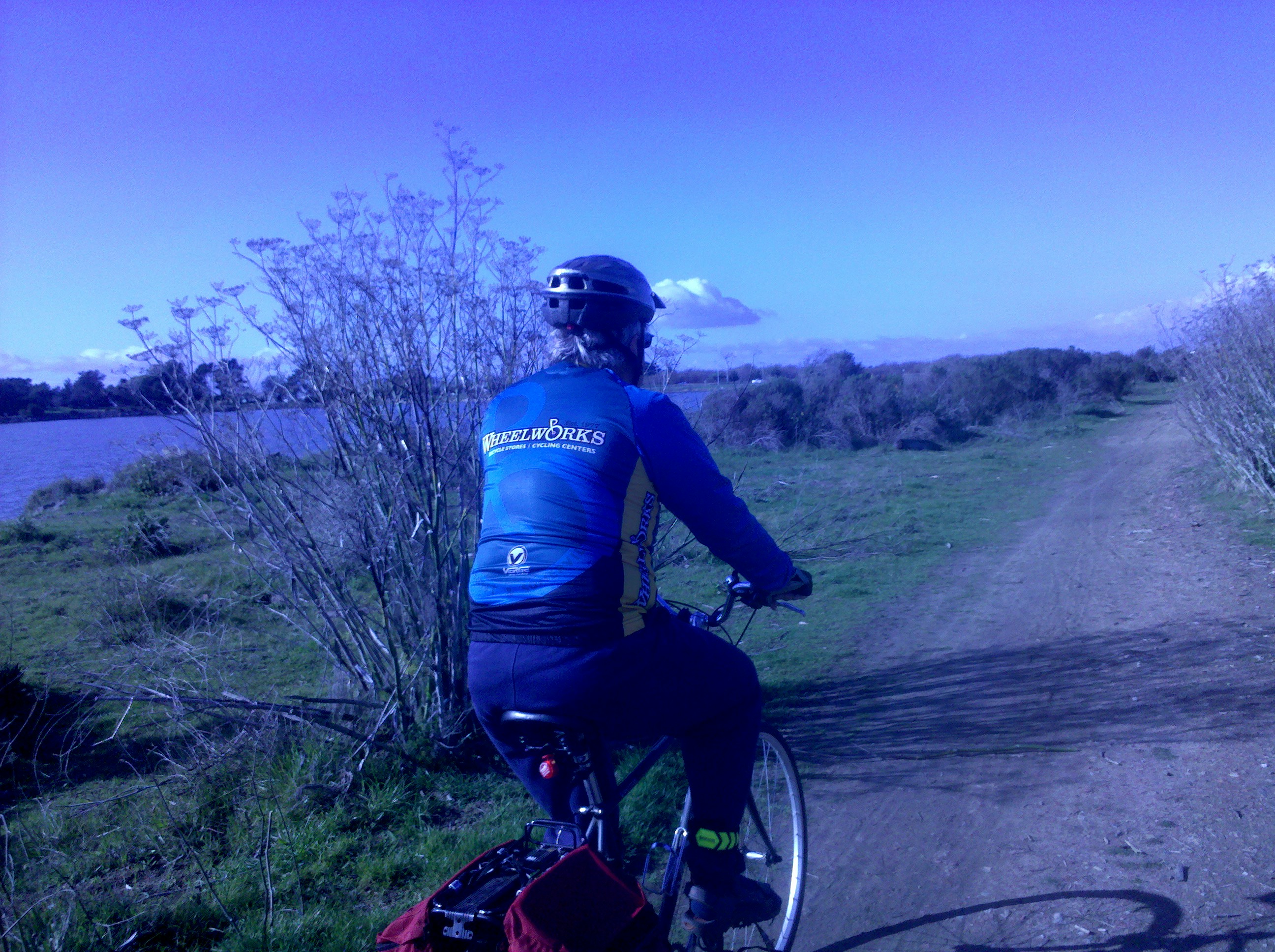
Do you ride your bike, walk, hike, jog or otherwise enjoy the Albany Bulb & Neck areas? Do you want to continue to have access so you can enjoy the Albany Waterfront to its fullest? Both pieces are scheduled to be transferred to the East Bay Regional Park District and some groups and individuals want to curtail recreational use. Further details about the process and possibilities are here on our website.
This meeting will be the first opportunity to give PUBLIC INPUT saying that yes, recreational access is important to you and your family!
More details will be posted as we have more information but please save the date to make sure we have access to OUR WATERFRONT! Speak up, or we are in danger of losing recreational access.
Some materials related to this effort are found here:
1. Conservancy Staff Report 5-29-2014
2. WRT_Albany Neck & Bulb Stakeholder Meeting_Access and Recreation
3. Scope of Consultant Services for Albany Neck and Bulb Transition Plan
Want bike trails like this along our beautiful Bay? Speak up!
Do you or your family ride to the Tom Bates ball fields, the Bay Trail, César Chávez Park, Emeryville or anywhere else passing along Gilman and the I-80 interchange? Would you rather have a safer, more pleasant ride? Here’s an opportunity to give input so that happens.
In 2014, Caltrans gave the City of Berkeley permission to move ahead with plans for double-roundabouts at the I-80 and Gilman Street interchange, located in West Berkeley near the boundary with the City of Albany. 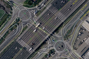
Such roundabouts are not friendly to active transportation. Consequently an active transportation overpass of I-80 and the West Frontage Road is proposed as part of the project. This project element is not shown on the schematic to the right because it was a late addition.
Unfortunately the overpass is to the south rather than north of Gilman. In this position it will require users to go more than a thousand feet out of their way after navigating the congestion on Gilman and crossing through motorist traffic on that street to reach the overpass.
As if that is not bad enough, the Alameda County Transportation Expenditure Plan also includes building a railroad underpass on Gilman. This information has not been included in or mentioned as part of the context for the current project in the publicity so far. This underpass will make the active transportation overpass even less desirable to reach by those it would otherwise best serve.
There is another option that should be studied – placing the overpass north of Gilman. This could connect to the Codornices Creek path upon construction, or be built to facilitate such connection in the future. This would provide a motorist-separated approach that matches the overpass. It would allow people to ride from Hearst and Milvia in Berkeley all the way to the Bay Trail entirely on cycling paths except for the few low motorist-volume blocks of Dartmouth between the Ohlone Greenway and San Pablo. It would also directly connect the two sports complexes at either end. For these reasons, Albany’s Active Transportation Plan is the only one that shows an overpass in this area, and it shows it at Codornices Creek not Gilman.
The project engineering consultant has said the northern crossing was not studied because it would require some right-of-way from Golden Gate Fields. However there is precedent for garnering land from Golden Gate Fields for active transportation facilities. The East Bay Regional Park District successfully used eminent domain to secure property from Golden Gate Fields along the shoreline for the Bay Trail.
The Alameda County Transportation Commission, City of Berkeley, Caltrans, and the Consultant Team will prepare traffic studies, community outreach, preliminary engineering studies, and CEQA/NEPA environmental review studies. AS&R invites you to attend the first community meeting to share your thoughts on the Gilman Street interchange project! And if your thoughts include studying a northern alignment for the active transportation overpass, please let them know.
Want to ride to the meeting from Albany? Leave a comment here with a suggestion and make it happen!
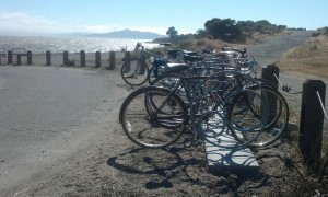
These racks that AS&R funded at the Waterfront are perfectly situated for folks who want to enjoy the beach, a hike or just enjoy the beautiful view.
Help keep our access there!
Do you ride your bike, walk, hike, jog or otherwise enjoy the Albany Bulb & Neck areas? Do you want to continue to have access so you can enjoy the Albany Waterfront to its fullest? Both pieces are scheduled to be transferred to the East Bay Regional Park District and some groups and individuals want to curtail recreational use and bicycle access.
The City is completing its “Albany Neck & Bulb Transition Improvement Plan” public process so this meeting is your final opportunity to give your input in order to ensure that the Waterfront area is something that can be enjoyed by all.
Representatives from Albany Strollers & Rollers and Bicycle Trails Council of the East Bay were invited to a Stakeholder meeting with Albany City Staff and the Planning & Design Consultants, and we were able to voice our opinions.
BUT it is crucial that City Staff, Consultants and City Council hear from YOU AND YOUR FAMILY TO SET FORTH PRIORITIES and a plan to communicate to EBRPD.

Want to ride along our beautiful Bay? Speak up!
Bike & hiking paths? Bathrooms? Bike racks? Picnic tables? Improved bicycle access from all directions?
What would make this a great recreational area, like the areas that Berkeley has in its Marina?
This City Council meeting is the FINAL PUBLIC FORUM TO SAY THAT YES, RECREATIONAL ACCESS IS IMPORTANT TO YOU AND YOUR FAMILY!
Consultants from WRT will give a brief presentation on the process and the final study, and there will be an opportunity for public comment.
More details will be posted as we have more information but please save the date to make sure we keep access to OUR WATERFRONT!
We risk losing access to our Bay if we don’t speak up!
Written comments can be provided in advance of the meeting to cityhall@albanyca.org. We encourage written comments be sent before the day of the meeting to ensure they can be taken into consideration.
Documents related to this effort are included here:
1. Final Albany Neck & Bulb Transition Study (very large – 143 pages)
2. Conservancy Staff Report 05-29-2014
3. WRT_Albany Neck & Bulb Stakeholder Meeting_Access and Recreation
4. Scope of Consultant Services for Albany Neck and Bulb Transition Plan
5. WRT Transition Improvement Plan as of April 2015
These racks that AS&R bought are perfectly situated for folks who want to enjoy the beach, a hike or just enjoy the beautiful view.
Help give input to make the Waterfront even more enjoyable!
The Bay Conservation & Development Commission will hold a Hearing on the Albany Beach Project.
Albany Beach Restoration & Public Access Project (first review) is the first actual agenda item of the meeting.
Won’t it be nice when we have a Bay Trail Connection through Albany?
The Design Review Board will review the design by the East Bay Regional Parks District, Questa Engineering, and 2M Associates for the Albany Beach Restoration and Public Access Project in the Cities of Albany and Berkeley, adjacent to Golden Gate Fields. The project would enhance the existing beach and dunes and would create approximately 4,765 linear feet of new Bay Trail, overlooks, and a 20-space parking lot.
Link to Meeting Materials which includes exhibits for the above which is Item 4 (but the first actual agenda item) on the Tentative Agenda.
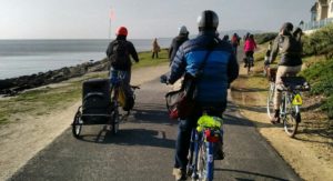
Help ensure that Albany’s segment of the Bay Trail will be completed, and safe & fun for all!
After a group of Albany residents, including fellow Strollers & Rollers, pointed out improvements that should be made to our Waterfront, there will be a chance to see the plans and give input on the Albany Bay Trail and beach project, officially known as the Albany Beach Restoration and Public Access Project.
Let’s make sure that OUR Waterfront is optimized for people who want to bike, walk, stroll and roll. There is a lot of car parking, but not nearly as much attention paid to parking for bicycles.
Note: a quorum of the City Council and/or an advisory body to the City Council may be present at this public meeting.
Here is the site plan
And the existing conditions map
And the complete packet from the most recent public meeting (April 17), which was at the San Francisco Bay Conservation and Development Commission Design Review Board. This packet has cross-sections and more detailed plans and a staff report.
Albany resident and landscape architect Hugo Larman drafted this updated plan based on community input, which expands the beach area, adds bike racks and moves car parking near existing parking.
EIR and other info from EBRPD (scroll down to where is says “Albany Beach Habitat Restoration and Public Access Project.”)
These racks that AS&R bought are perfectly situated for folks who want to enjoy the beach, a hike or just enjoy the beautiful view, but they are lonely! We need more “there” at the Waterfront, and more bike racks near other destinations.
AS&R member Dan Johnson prepared comments and alternative plans . After further discussion, Dan & others believe that the location for parking might not be feasible. However his diagram about the amount of paving is relevant.
While not a part of EBRPD’s plan, the Albany Waterfront Committee’s Cove Enhancement Plan should be completed by the City of Albany and taken into account by EBRPD for a comprehensive plan at the entire waterfront. The only reason it was not completed in 2012 was because EBRPD requested the City hold off because of upcoming construction. That reason is long past.
In response to recent community comments, the designers are making efforts to reduce the large amount of pavement for the vehicle driveway and turnaround to leave more open space for recreation at the south end of the site. However, a number of us believe that it would be more functional and would preserve more open space (as well as reduce bicycle-pedestrian conflicts) to locate the parking near the existing parking, on the north side of Buchanan St., which would eliminate the need for the long driveway. However, this area is City-owned and outside the EBRPD project area.