Discounts Become an AS&R member and get discounts at local bike shops and businesses!
Blue Heron Bikes: 10% off parts and accessories.
Bikes on Solano: 10% off labor, parts and accessories.
Offers are valid to members of Albany Strollers & Rollers and their households. Tell your friends!
Contact us with questions.
|
Under the wonderful leadership of Susan Chang, the project manager for the Gilman interchange project, the tradeoffs regarding different possible alignments for the Gilman overpass are becoming clear. While the tradeoff analysis is not yet final, the effort appears to have crested and is now rolling downhill. So it is a good time to share some of the preliminary findings and ask for your thoughts. Please share them by submitting a comment below this article in the hopes this page will provide a pan Albany-Berkeley conversation.
The request to the Alameda CTC to consider northern alignments in addition to the southern alignment started with the surmise that there are more potential users north than south of Gilman. All data collection and analysis since has confirmed this. Below is a map showing biking and walking sheds north and south of Gilman according to routing by google maps to the Gilman fields. Whatever algorithm Google developed for cycling routes appears to accurately replicate the route most people would prefer (most people preferring low stress over high speed and directness). For instance it connects points south of University with the fields via the University active transportation bridge and the Bay Trail, and points west of San Pablo in southeastern Richmond via the Ohlone Greenway and Gilman. Note points in the hills are not included due to the much lower likelihood of people living there biking and walking to the waterfront.

Following are population distributions by distance from the fields in each bike shed. After that is the distribution of 5 to 18 year olds. The columns fade toward the right of the chart to qualitatively indicate the decreasing the likelihood of someone biking or walking to the fields with distance.
 
The charts show there are far more people north of Gilman than south at all distances other than 2 to 3 mi., and far more 5 to 18 years olds at all distances north than south. After discussion by the alignment working group, Alameda CTC also paid for maps of the home census block group of cell phones that visited the Gilman fields this past September. These data show that at least 7% of cell phones were from homes within 2 mi. in the active transportation shed north of Gilman and 3% south of Gilman. Two to three miles out, 4% were in the southern shed versus 2% in the northern shed. However the average elevation in the southern shed at these distances is substantially larger than in the northern shed.
So in the context of roughly twice as much demand for the overpass from north of Gilman than south, what is the best alignment? The work group has considered something like twelve different northern alignments to date. Two have risen to the top at this time. Both of these provide for three potential options for making a connection with no motorist crossings to the Codornices Creek trail in the future. Neither makes that connection now because it would add at least $10 million dollars to the cost, be outside the project scope, and delay the project by years. The delay would result in Alameda CTC losing a grant for the overpass, and also risk that Alameda CTC would abandon its lead role on the overpass project.
One of the two northern alignments of most interest is essentially a mirror of the southern alignment as shown on the map below. The other northern alignment is similar except it extends the western leg over Gilman to the midpoint between the north and south entrances to the fields. As part of either northern alignment the two-way cycletrack on Gilman west of Fourth would be on the northern side.
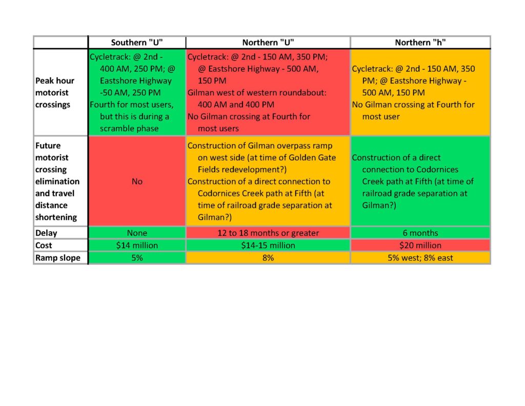
There are a number of advantages and disadvantages to each alignment, summarized in the table below. The matter appears to come down to the importance of accommodating a future connection that eliminates all motorist crossings west of Sixth, shortens travel distance on average, and avoids routing overpass users through a railroad underpass on Gilman if that is built. Red for the southern U below is based on considering these quite important. Whether it is important enough to prefer the disadvantages of each northern alignment is a judgment call based on the number of additional people that would use a northern alignment extending from Fifth and Codornices Creek to the Gilman fields without any motorist crossings in the future as compared to the southern U. Methods for analyzing active transportation travel demand are not sufficiently developed at this time to provide a quantitative answer. So what do you think? Please enter your thoughts in comments below.
A year ago, AS&R sent a letter regarding active transportation elements of the proposed Gilman interchange project. It was joined by the Berkeley Climate Action Coalition’s Transportation Working Group, Bike East Bay, the Albany Berkeley Soccer Club, Berkeley Rhino Rugby Club, Berkeley Rugby Football Club, and Berkeley Lacrosse Club. Until two weeks ago, Alameda CTC, the lead agency for the project to whom the letter was sent, had not responded.
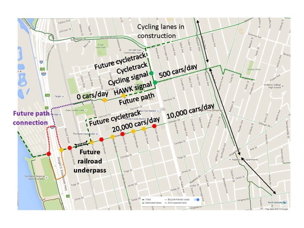
Fortunately, during the year of silence Alameda CTC did direct the project engineer to analyze alternate alignments for the proposed overpass. At the time of the letter, only a southern “U” overpass alignment was being pursued, as shown on the map below. The best alignment in terms of maximizing the number of people that would ride or walk to the waterfront connects the west end of the Codornices Creek Trail to the Bay Trail at Gilman. This is because studies show connecting a new path to an existing path results in more people riding the new path than connecting a new path to a cycling facility on a street. Also, the majority of the population that would use the overpass lives north of Gilman where the population density is higher and more Albany Berkeley Soccer Club players live. For instance, there are a thousand families with children in University Village a short distance north of the project compared to few residents similarly close south of the project.

The map also shows roads people cycling or using sidewalks would have to cross color coded by hazard, along with the average number of motorists traveling along the routes each day. The orange intersections along Gilman are signalized, or in the case of Fourth Street proposed to be signalized as part of the Gilman interchange project. The red intersections along Gilman are not signalized. Consequently motorists can turn right and left from Gilman onto those streets across the path people would have to take to an overpass at either the southern or northern “U” alignments. In particular, the intersection at Second Street cannot be signalized because doing so would cause motorist backups into the eastern roundabout, which could cause grid lock. At the same time, the roundabout design also requires that motorists headed north or south on Eastshore Highway from Gilman do so via Second Street. Consequently there would be many motorists turning from Gilman onto Second.
In contrast, the desired connection to the Codornices Creek Trail requires users to only cross two streets with fewer motorists midblock, which is much safer. However because this desired connection involves two overpasses as well as alignment along the creek in part, the groups sending the letter decided garnering this alignment in one go was likely too much of an ask. Consequently the groups asked Alameda CTC to consider a northern “U” alignment that would allow for connection to a railroad overpass to the Codornices Creek trail in the future.
Last week Alameda CTC shared the three alignments it has studied. The southern “U” primary alignment is shown first below (in green going across the freeway in the left side of the map). As compared to the previously available design iteration, a two-way cycle track on the south side of Gilman is proposed connecting to the overpass (shown in purple). However, as mentioned, users of this facility would have to cross through motorists on Gilman turning into Second Street without any signal protection.

Next is the northern “U” alignment requested in the letter. While not shown, conversation with Berkeley Transportation Division staff suggests a two-way cycle track on the north side of Gilman connecting to the northern “U” alignment is likely as feasible as one on the south side connecting to the southern “U” alignment.

Finally, and with surprise, Alameda CTC studied a northern “L” alignment directly connecting the west end of Codornices Creek trail (where there are sports fields) and the Bay Trail south of Gilman (where there are also sports fields).

It found all of these alignments feasible in terms of engineering. However they differ in cost and how soon they could be implemented. This is due to differences in available funding as well as the need to acquire right of way for the northern alignments, and engineer and permit the portion of the path along Codornices Creek.
The meeting with Alameda CTC last week brought forward a hybrid option, the northern “h” alignment (the lower case “h” reflects the term “hybrid” as well as the longer western leg in the near term and future northern connection on the east side in the long term). This combines the eastern leg and freeway overpass of the northern “U” with the western leg of the northern “L.” The advantage of this is that it precludes users from the north, which are the majority, from having to cross through motorist traffic on Gilman at all.
Each of these options has pros and cons, as shown on the table below. Alameda CTC is hoping that all the stakeholders can agree on pursuing one alignment at this time in order to simplify its effort going forward, which translates to time and cost saved. The alignments are ordered from least usable but most achievable in the short term, to most usable but least achievable in the short term. The northern “U” and northern “h” have the option of being extended to Codornices Creek in the long term. This could occur in particular as a mitigation if the railroad underpass on Gilman specified in the County Transportation Expenditure Plan moves forward.
Which alignment do you think AS&R and the other groups should pursue? Leave a comment below or send a message to the AS&R discussion list (albany@lists.ebbc.org) or BCAC TWG google group (bcac-transportation-wg@googlegroups.com) if you are a member. Alameda CTC is hoping to make this decision early the week of October 16th, so your response before then will have the most impact.

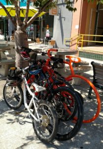
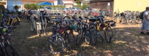 Bikes, Bikes, Bikes!! You, your neighbors and friends with AS&R parked 300 + of them at our two lots! Photo courtesy Nick Pilch The 43rd annual Solano Avenue Stroll was a rockin’ and rollin’ success, thanks to our fabulous volunteers! Albany Strollers & Rollers again managed two Bicycle Valet Parking lots for the event, in the lot below Masonic in Albany, and at the top of Solano in the Wells Fargo lot in Berkeley. The weather was hot and the cyclists came out in droves – we parked more than 300 bikes in both lots, and our own 18 “Moved By Bikes” Valet Racks were up to the task!
 Our volunteers kept things running like clockwork at both lots
Photo courtesy Patsy Reese Thank you to all our Bicycle Valet Parking volunteers, led by Sylvia Paull, Eli Cochran, Mac McCurdy and rackmeister Ken McCroskey.
Barb & Mark Altenberg, Joseph Friedman, Griffin Neal, Shauniece Williams, Samantha Hampton, Mike Gill, Anne Malamud, Eddie Chau, Jane Lenoir, Bryce & Lyell Nesbitt, Tony Caine, Brian Beall, Lai Yuling, Patsy Reese, Stacy Loucks and Maribeth Hutson all helped check in, park and retrieve bikes. We needed every single one of you to make the operation go smoothly!
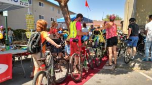 A steady stream of cyclists rolled up the Red Carpet into our west lot all day!
Photo courtesy Amy The coolest addition to our BVP service was the Masonic lot’s “Red Carpet,” donated by Janka at Floor Dimensions, which led cyclists up our ramp into our lot – very glamorous!
Many people told me specifically that if we hadn’t been there they wouldn’t have come to the Stroll at all – too far to walk, but a hassle to drive.
Mike Cabanatuan & Michael Primmer were the absolute kings of the AS&R table setup. The two of them, Valerie Risk, Kim Van Eyck, Sherie Reineman, Nick Pilch and I (Amy) had a great time engaging people and doing outreach on behalf of AS&R and cycling in general. We spoke to so many Stroll-goers of all ages, answered questions about all aspects of bicycles, bicycling & walking, made some great connections to help us facilitate more racks at the Middle School, signed up a handful of new members (welcome!!,) sold a bunch of “Check for Bikes” clings & bumper stickers and one BikeLink bike locker card… and our reflective leg bands were flying off the shelves!
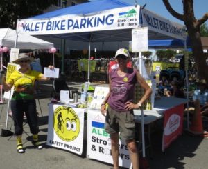 Sherie & Amy held down the fort (the AS&R table) most of the afternoon Photo courtesy Patsy If many of the names above sound familiar, they should! Some of our volunteers were veterans who have helped us at previous events and know the ropes. AS&R’s event rookies brought much-needed new energy and were a HUGE help. All were terrific and got major kudos from everyone who came by!
A big shout-out to Pat, owner of local businesses Bua Luang Thai Cuisine & Tay Tah Café, for again sponsoring our BVP service and providing delicious lunches & coupons for some volunteers. Pat’s support is so important and we really appreciate the effort she puts into helping us in all our events. Bhimsen of the new restaurant Mountain Mike’s Pizza at the top of Solano provided lunch and coupons to the volunteers at the Wells Fargo lot so we all had plenty of food!
 We appreciate the continuing support of Pat from Tay Tah and Bua Luang – thanks for the lunches and coupons!!
Photo courtesy Amy Smolens Lucas Euser of ClifBar donated hundreds of Clif Bars, Organic Z Bars and Fruit for all the volunteers and many visitors, too! On a hot day like Sunday, believe me, we all needed the extra energy!
Special thanks to Grizzly Peak Cyclists who lent us their two pop-up tents via Sherie, and to Brad & Linda Carlton, who lent us their folding tables.
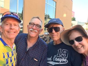 Doesn’t it look like the late crew of Mike, Eli, Mac & Patsy had a great time? You can, too, if you join us at our next event! Selfie courtesy Mike Gill A final thank you goes out to the Solano Avenue Association, which makes Bicycle Valet Parking a priority for this huge regional event and puts us in a position to succeed every year. It’s an honor to be associated with one of the region’s longest-running and best street fairs!
We hope that YOU will be there for #44!
Thanks, all!
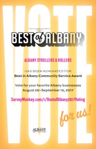 Cast your vote for AS&R and your favorite local businesses in the “Best of Albany” competition by September 15th! We are excited to announce that your very own organization, Albany Strollers & Rollers, has been nominated for the Best of Albany in the category of ‘Best in Albany Community Service Award!’ Voting has begun and will run through September 15. Be sure to vote for AS&R and for your other favorite restaurants, activities and other categories here – pass the link on to your friends, family & neighbors and through social media.
 If you, your family or your neighbors use the bike racks that AS&R have funded around town please show your appreciation by voting for us – thanks!! If you’ve used our racks or public pumps, ridden the roads or paths that we’ve helped improved, or parked in our Bicycle Valet Parking lots at events, please cast your vote for us, as well as voting for your favorite Albany businesses.
If we win, we will ALL share in the pride of what we have accomplished in and around Albany.
 Do you or your family ride on the Ohlone Greenway? Sure you do! Please vote for AS&R, who improved it for you!
Albany Strollers & Rollers (AS&R) is pleased to have had a number of recent successes such as:
- Successfully advocated for the new cycletrack in front of the UC Village development (Sprouts, additional retail, and senior housing)
- 8 new “Bike Bike Racks” and one “Air Kit” bicycle pump around the city in the past year, for a total of 56 Bike Bike Racks and two Air Kits
- Passage of the sidewalk tax to fund badly needed sidewalk repair
- Pledged $1,000 to help fund the Public Parklet on Lower Solano Avenue
- Pledged $1,000 to fully fund new bike racks at Albany High School
- Successfully advocated for and managed safe and well located bike racks at Safeway and UC Village development
 We have 56 of these Bike Bike Racks around town! What’s next?? YOU DECIDE!! Now we are wondering what our next priorities should be. And so we turn to YOU – what are your new burning ideas? What do you want to see done? What problems have you seen biking and walking to work, the store, or to school? We can support you in getting things done – for yourselves, your neighbors, and your children! Come out and talk to us at our next General Meeting on Sunday July 16, 4-6pm at St. Alban’s.
AS&R recently learned the East Bay Regional Park District has developed 30% engineering drawings of the Bay Trail segment it will construct between Buchanan and Gilman. These drawings could not be readily found on the web, so AS&R reached out for help acquiring them. Several members successfully jumped on it, so now AS&R and you have access to a slide deck showing more detail regarding the planned segment. AS&R has not acquired the actually engineering drawings yet, but will keep trying.
Here is the map from the slides regarding the planned trail.
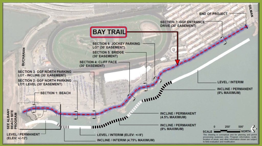
An interesting aspect of the design is its treatment of flood levels now and in 2050 with sea level rise. In the above map, portions of the trail are indicated as either permanent or interim. Looking at the trail cross sections in the slides indicates the northern interim portion will be below the 2050 sea level plus 100 flood. The southern interim portion will be above this static water level, but a note relays that with storm surge and wave action water can actually lap up to 2.5 ft higher than the static level. At this level, the southern interim portion would likely be underwater as well.
The other portions are either along Fleming Point or the expanded beach area to be built. The portions along Fleming Point are obviously elevated, so engineering relative to current and future water levels is not necessary. The portion along the planned expanded beach will be built up so it is above water levels for the foreseeable future.
In contrast, both of the interim portions are between the shore and a near sea level portion of Golden Gate Fields. It may be that EBRPD did not want to burden the project with the cost of elevating the trail in these portions because this would increase the project cost by essentially building a levee, which in turn would provide substantial uncompensated benefit to Golden Gate Fields. EBRPD is perhaps instead taking the approach that Golden Gate Fields will eventually determine it is in its own interest to build a levee to protect its property, and at that time EBRPD could join with Golden Gate Fields on a fair cost split. Note again this is all speculation based on the evidence of the slides.
As last reported, the Alameda County Transportation Commission’s (ACTC) grant application to fund construction of the active transportation overpass at Gilman it proposed was not funded. However at that time it had not been funded by the State. All unfunded applications are subsequently forwarded to the relevant regional transportation agency for consideration of funding from its portion of the available state active transportation money. In our area this agency would be the Metropolitan Transportation Commission (MTC). Fortunately, in late December MTC also declined to fund this proposed overpass.
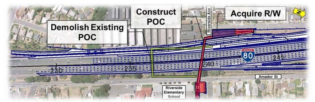
This gives ACTC a chance, and hopefully the motivation, to actually engage with the community to design an overpass that works for everyone. As mentioned in the last post on this topic, a good model exists just a bit to the north. The following figure shows the old overpass of I-80 south of San Pablo Dam Road landing between the freeway and the frontage road on the east side, and the new overpass crossing both. AS&R just sent ACTC a letter pointing out that this overpass crosses both the freeway and frontage road as a result of engaging and listening to the community.
 Information available on the web indicates this new overpass has been completed and is now open. If you have used this overpass, or happen to use it in the future, please leave a comment below describing your experience and thoughts. Information available on the web indicates this new overpass has been completed and is now open. If you have used this overpass, or happen to use it in the future, please leave a comment below describing your experience and thoughts.
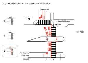
The “final” design of the active transportation facilities along the portion of San Pablo fronting the University Village Mixed Use project was shown to the Traffic and Safety Commission at its December meeting. To AS&R’s surprise, the proposed signalized active transportation crossing of San Pablo at Dartmouth did not include accommodation for people cycling. Here is the design presented. Note in particular that the curb opening on the west side of San Pablo is only as wide as the crosswalk, thus requiring people to enter that crosswalk to access the cycle track. However riding in a crosswalk is illegal if it is not a connection along a cycling path, which it is not in this case.

City staff explained they had presented CalTrans with a schematic design that included the cycling crossing, but CalTrans rejected that component. The issue is that the type of signal (a HAWK or hybrid pedestrian beacon) has a solid red phase through which motorists cannot proceed following by a trailing flashing red phase that requires motorists to stop, let any sidewalk users cross, and then proceed. As such, it does not protect people biking across.
To solve this, a cycling signal head facing people crossing San Pablo is needed to tell them when the facing motorists on San Pablo is solid red and so it is safe to cycle across. However, combining cycling signal heads with a HAWK signal is not provided for in engineering standards. So they can only be added under provisions for experimentation. This requires far more overhead in terms of document preparation, meeting attendance, and data collection. However subsequent to the Traffic and Safety Commission meeting, staff committed to pursue this process with CalTrans.
Here is the ultimate design AS&R has requested. If you would like more details, see AS&R’s and Bike East Bay’s letter to Albany staff.
AS&R has sent a letter to the Berkeley City Council, Transportation Commission, and Transportation Division providing input on Berkeley’s draft Bike Plan. Chief among this input is asking that the plan include connections on Berkeley’s side to all the cycling routes proposed in Albany’s Active Transportation Plan (ATP). Most of these connections were already proposed in the version of the Berkeley Bike Plan available for the October 20th Transportation Commission meeting, but a couple were missing.
Below this input, AS&R suggested the organizing vision for improving the bike boulevards of seeking to make cycling west (downhill), and north and south (cross slope) faster than motorists can travel on the adjacent arterials during peak traffic periods. This is required in order to motivate a substantial percentage of people to switch to biking for some of their trips.
In accord with this, AS&R asked that the Berkeley plan optimize the bike boulevards for cycling by replacing diagonal diverters with more friendly semi diverters or other motorist barriers, eliminating stop signs, and improving crossings of motorist arterials other than with the rectangular rapid flashing beacons (RRFBs) in the current plan. Paraphasing Transportation Division staff, RRFBs are planned because they are cheap, even though they may be fatal because they do not actually give people biking the legal right of way to cross when activated.
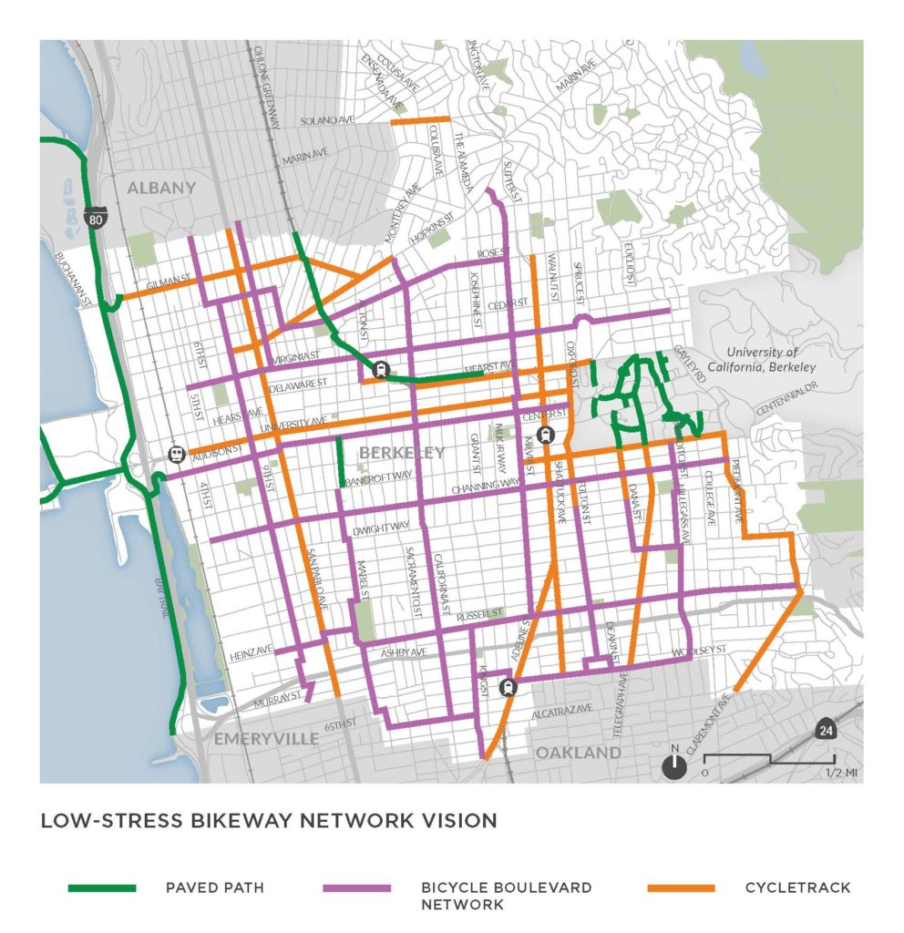 AS&R also asked Berkeley to define a rapid cycling network in addition to the low-stress network it has defined, as was done in Albany’s ATP. It suggested that route signage should be uniform within each network rather than along each route type as this would facilitate people connecting across all route types with a specific network, which is their desire. AS&R also asked Berkeley to define a rapid cycling network in addition to the low-stress network it has defined, as was done in Albany’s ATP. It suggested that route signage should be uniform within each network rather than along each route type as this would facilitate people connecting across all route types with a specific network, which is their desire.
Finally, AS&R asked that the plan be named something other than “Bike Plan” as that is a misnomer with regard to its goal of getting more people biking.
You can read the full letter here if you like. You can download the draft plan here.
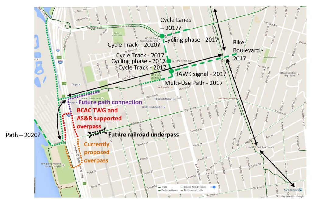
Last September, AS&R joined with numerous other organizations (the Berkeley Climate Action Coalition, Bike East Bay and the Albany Berkeley Soccer Club among others) to send a letter to the Alameda County Transportation Commission (ACTC) panning various aspects of its active transportation design for the I-80/Gilman interchange reconstruction, chief among these the proposed multi-million dollar active transportation overpass. You can read the letter at bcac-twg-asr-gilman. One of the key maps from the letter is shown below.
ACTC applied for over $8 million from state active transportation program cycle 3 to partially fund construction of the proposed overpass. Fortunately this application was not funded. AS&R has no knowledge whether or not the letter played a role in this decision.
Hopefully this result will motivate ACTC to take the concerns of the community seriously, and revamp the design. AS&R recently learned of an example of a flawed active transportation overpass not five miles away that provides a further red warning light regarding the design proposed by ACTC. The Riverside crossing of I-80 in Richmond is being completely replaced as part of an interchange reconstruction project there. The eastern landing of the previous overpass was between the frontage road and the freeway, like the overpass ACTC proposes at Gilman. Unlike at Gilman though, the planners and engineers of the new Riverside overpass engaged with the community. The community’s main request was to land the eastern side of the overpass on the east side of the frontage road so people did not have to expose themselves to the hazard of motorists on the frontage road in order to access the overpass. The planners and engineers listened, and the new overpass with this configuration will be opening soon.
It is amazing to have such a clear example of the correct outcome from a better process so close by. AS&R will send a followup letter to ACTC pointing out this example, and will seek to have the same broad range of signatories.
|
|