
AS&R & Bike East Bay’s joint letter of input (December 1, 2015 to City of Albany):
See link to letter: AS&R Marin Ph III input and content below:
1 December 2015
Aleida Andrino-Chavez
Transportation Planner
City of Albany
1000 San Pablo Avenue
Albany, CA 94706
Re: Marin Phase III cycling 90% project input
Dear Ms. Andrino-Chavez,
Albany Strollers & Rollers (AS&R) and Bike East Bay (BEB) propose some improvements, listed below, to the Marin Avenue Bikeway 90% plans dated July 2015. All of these changes regard pavement markings rather than hardscape. Under no circumstances do AS&R and BEB want these requests to delay the project. If any of these suggestions would require timeconsuming engineering consideration or negotiations with Caltrans, we ask the City to begin the project as currently planned, and simultaneously submit any changes regarding San Pablo to Caltrans for separate approval. If Caltrans approves in time, the project could be built incorporating the changes; otherwise, the changes can be implemented in the future when approval is received.
1) Bike lane marking eastbound across San Pablo Avenue
Request: Add a pair of dotted lines to guide on-road bicyclists from the bike lane west
of San Pablo to the bike lane east of San Pablo Avenue.
Optional addition: Place a merge symbol near the east end of the intersection where
riders from the bike lane join those from the off-road path.
Analysis: The dotted lines will help people biking and motorists in the adjacent lane
maintain position across the intersection, which in turn will provide smoother
intersection operation and increased intersection capacity. The addition of these lines
should not affect the already-planned markings guiding bicyclists from the off-road
path to the bike lane. Rather, in combination these lines will indicate to people cycling eastbound on the road and from the path that they need to merge prior to entering the cycling lane on the far side of the intersection. This could either be implied by the striping, or actually indicated by a merge symbol toward the far side of the intersection.
2) Skip-green bike lane westbound across San Pablo Avenue
Request: Add a pair of dotted lines with intermittent green patches, starting a bit east
of the intersection and continuing through the intersection.
Fallback alternative: Add skip-green markings leading up to the intersection, with
sharrows across the intersection.
Analysis: The markings will guide westbound bicyclists through the north edge of the
intersection, while reducing “right hook” collisions by alerting right-turning motorists
that they are crossing a bike facility. Skip-green paint all the way would be best. If
Caltrans approval for skip-green paint across the intersection cannot be garnered in
time, the fallback alternative of sharrows may be more easily approved.
Such a pattern has been installed on eastbound 40th Street at San Pablo Avenue in
Emeryville, a virtually identical intersection. Sharrows were used across this
intersection because there are sharrows rather than a cycling lane departing from the
intersection on the far side. However, if this precedent makes it possible to garner
approval for sharrows in time for project implementation where it appears approval for
skip-green paint would not occur in time, sharrows are better than no markings at all
across the intersection as currently proposed.
3) Skip-green bike lane eastbound across Cornell Avenue
Request: Add a pair of dotted lines with intermittent green patches through the intersection.
Analysis: The markings will guide eastbound bicyclists as they cross Cornell Avenue,
while reducing “right hook” collisions by alerting right-turning motorists that they are
crossing a bike facility. This intersection seems at higher risk for right hooks than the
others in the project because the cycling facility just in advance of the intersection is
essentially Class IV (separated bikeway). As such, it does not include a transition to a
dashed line between the cycling facility and adjacent motorist lane prior to the
intersection. In a Class II facility, this dashed line informs motorists they need to merge
into the cycling lane prior to turning, with attendance to vehicle operators (people
cycling) to their right as with any lane change maneuver. Consequently without the
dash, some other means of signaling to motorists to use care turning across the cycling
facility is required.
The standard approach in the NACTO design guide for Class IV facilities is to continue the facility across the intersection with skip green paint. If these markings cannot be added to the project, AS&R still supports the Class IV facility leading up the intersection. This class of facility is planned to provide greater protection for people cycling at the location where motorists must merge from two to one through lane. This merge puts people cycling in the target zone of motorists who merge late, and so AS&R finds the increased protection offered by a Class IV facility is warranted. This allows for raising this segment of the facility to a grade-separated Class IV in the future if conflicts between motorists and people biking occur with the proposed at-grade Class IV facility.
4) Adjust door zone width allocation
Request: Paint a 4.5-foot bike lane and a 2.5-foot door zone buffer, instead of the 4-
foot bike lane and 3-foot door zone shown in the plans.
Analysis: Research published by the Transportation Research Board a year ago last
summer supports this request.*
The Board collected and analyzed field data regarding how far motorists park and drive and people bike from the curb given various cycling lane and buffer configurations. Based on this research, the Board recommended a 7’-3’-4’ or 7’-2’-5’ parking lane, door zone buffer, cycling lane widths when 14’ of width is available next to a 10’ wide motorist lane. This analysis assumed a fully open vehicle door extends 45” from the vehicle. Because this is an overestimate for the mix of vehicles parked in Albany, and because the project is along a residential street with typically low parking turnover, AS&R supports a compromise between the two Transportation Research Board recommended configurations. This will provide a wider, and so more comfortable, cycling lane than currently proposed, while still offering substantial protection against door zone collisions for people riding fully in the lane.
Thank you for your consideration of these suggested changes to pavement markings in the project. If you have any feedback or questions, please feel free to contact AS&R via Preston Jordan at pdjordan@lbl.gov.
Respectfully,
Preston Jordan
Co-founder
Albany Strollers and Rollers
Dave Campbell
Advocacy Director
Bike East Bay
______________
* http://onlinepubs.trb.org/onlinepubs/nchrp/nchrp_rpt_766.pdf
* * * * * * * * * * * * * * * * * * * * * * * * * * * * * * * *
Project Update (February 13, 2013):
Aleida Andrino-Chavez (City of Albany’s Transportation Planner) provided us with this photo (sent by Ana Bernardes in Public Works who is overseeing the construction of the project). Please note the new, improved curb-cuts at Buchanan/Pierce where the new cycling ramp / plaza meets the street. Kudos to the City staff for making this happen!
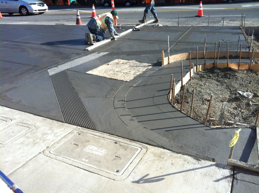
new curb-cut with wider access to the ramp will accomodate cyclists and pedestrians traveling in opposite directions
Background on this project followed by the history of AS&Rs engagement are available at the bottom of this page.
24 June 2012
Council considered the 100% design for this project at its meeting on June 18th. It approved the design with direction to staff to seek better accommodation for people walking and cycling through the intersection of Marin and San Pablo. While the official motion did not specify the addition of the cycling lane along the right turn lane sought by AS&R, the context for the motion indicates staff should and will seek such a lane as a result of the motion.
During the staff report, the City Engineer showed the project design on Marin at San Pablo with a cycling lane and the necessary additional width of easement from UC shown in color. This and other staff comments indicates highest level staff understand the issue now and will seek to correct it. Key to this was staff conveying that the lane could be added as a change order, which provides considerably more time to work out the solution. The project must go to bid in the next few months, which was an extremely short timeline for adding the lane into the design otherwise.
The other motivation for Council’s broader motion is that staff made clear the right turn lane is not providing the desired improvement for people walking across San Pablo at this time either. Staff’s hoped for improvement was a pedestrian leadoff phase. This turns the walking sign green before signal for motorists traveling in the parallel direction turns green. This allows users to occupy the crosswalk before motorists start moving, which improves motorists safely yielding right-of-way to crosswalk users as legally required. Staff’s hope was that the intersection motorist capacity increase provided by the right turn lane would offset the motorist capacity decrease caused by implementing the pedestrian leadoff phase such that CalTrans would commit to implementing the latter (CalTrans controls San Pablo).
As mentioned below, CalTrans has not committed to implement this phase, but rather has replied that it will make a decision once the project is built. Staff noted this, and noted that Albany has a separate grant for implementing cycling lanes on Marin from San Pablo to Cornell to the east. The City had intended to pursue this after the Buchanan cycling improvement project west of San Pablo is completed, in part as a matter of staff capacity. This grant has funds for changing the signal at Marin and San Pablo, which are sufficient for adding a right turn signal head to control eastbound motorists. This would provide a real benefit for users of the crosswalk across the south side of the intersection.
So to deal with the near term uncertainty that CalTrans is going to provide any benefit to crosswalk users in response to the addition of the right turn lane, staff suggested it could accelerate implementation of the next phase project in order to maximize the likelihood of benefit for those users. Council’s motion was affirmed that staff should take this action as well. Of course, even with money for significant signal changes, CalTrans still may balk at balancing this intersections function for a broader range of users. AS&R will have to monitor the situation and take action if necessary.
18 June 2012
The photo below shows a cycling lane between right and through turn lanes for motorists, such as AS&R is seeking to have added to the Marin/Buchanan cycling improvement project. The City Council is considering approval of the final design, which lacks a cycling lane along the planned new right turn lane currently.

The view is looking to the east at Tennyson from Hesperian in Hayward (from Google Streetview). Less than one fifth the percentage of workers cycles to work in Hayward as in Albany, yet Hayward got this done right while Albany is struggling.
14 June 2012
The first phase of this project is to improve cycling access along Marin/Buchanan from San Pablo to the existing path on the Buchanan overpass to the west.
Albany Strollers & Roller’s current concern with this project is the lack of a cycling accommodation relative to a planned additional lane on eastbound Marin west of San Pablo. This additional lane is for motorists turning right onto San Pablo. The map below illustrates the situation with the current plan.

Without a cycling lane in this location, people biking through eastbound on the road will either follow the curb, and potentially collide with right turning motorists (a “right hook” collision), or have to bike between two lanes of motorists traveling up to 30 miles per hour. Consequently the right turn lane would degrade, rather than enhance, conditions for some cyclists. This would be an ironic outcome of this cycling improvement project, to say the least.
In addition, it is not clear why the City is paying to add this lane. It is a required mitigation for the proposed University Village Mixed-Use Project (also known as the “Whole Foods” project). If that project were built, the private developers would have to pay for installation of this lane.
If the cycling lane cannot be included, Albany Strollers & Rollers wants the right turn lane eliminated.
Please write the Albany City Council at cityhall@albanyca.org, attend the Council’s meeting on Monday, June 18th starting at about 8:30 pm and comment, and/or contact your favorite Council member to discuss this directly.
(15 June addendum: review of AS&R’s email exchanges with staff over the past three months recovered the information that staff decided to include the right turn lane in the hope it would motivate a commitment from CalTrans to change the signal phasing to accommodate people crossing San Pablo to and from the path in the future. Given CalTrans historic focus on accommodating motorists at the exclusion of everyone else, this was a risky strategy. Not surprisingly, CalTrans responded that it will not commit to changing the signal phasing, but will decide what to do after the lane is built.)
Project Background
The Marin/Buchanan cycling improvement project will close the gap in the cycling route between the end of the cycling lanes at Cornell on the east and the path on the Buchanan railroad overpass to the west. The project will install cycling lanes between Cornell and San Pablo, a multi-use path along the south side of Marin and Buchanan from San Pablo to Pierce, a cycling lane in the westbound direction along this same segment, and sharrows on this segment in the eastbound direction. A signal at Pierce for path users will be installed to allows path users to be able to safely cross between the overpass and southside path. In addition the westbound Buchanan “spur” street that connects from Buchanan to Cleveland will be closed at Pierce in order to make the path connection safer.
Overall drawings of the final design are available at http://albanyca.org/Modules/ShowDocument.aspx?documentid=20371. However, these are difficult to read due to the patterning and symbology. The drawings showing the 35% design options are much easier to read. Those are available at http://albanyca.org/Modules/ShowDocument.aspx?documentid=9637. This document shows the alternatives designed for different segments. The City Council adopted Alternative 2 from the overpass to the USDA driveway, Option 1 along Ocean View Elementary School (the USDA driveway to Jackson), and Alternative 1 east of San Pablo (there was only one alternative from Jackson to San Pablo). The alternatives selected were supported by AS&R. Note the 35% plans do not show eastbound sharrows, which were added during the subsequent 100% design process.
The initial conceptual design was developed almost a decade ago by consultants TY Lin and Associates using funds ( tens of thousands of dollars) from the Metropolitan Transportation Commission (MTC). The 35% design was developed by a team of consultants led by AECOM (which had a different name at the time) paid for primarily by an approximately $300 thousand grant funded by Alameda County’s 0.5% sales tax to support transportation (Measure B). Albany funded the 100% design using its own funds. Most of the construction cost for phase 1 from San Pablo to the overpass is funded by a Congestion Management and Air Quality Improvement/Surface Transportation Program grant (a federal source) of $1.7 million from the MTC. Most of the construction cost for phase 2 from San Pablo to Cornell is funded by a State Bicycle Transportation Account grant of $600 thousand.
The project will also be coordinated with power and communication utility undergrounding from the overpass to Masonic, which make both efforts more cost effective and result in additional safety improvements for the City (overhead power lines are seismic safety risk).
History of AS&R’s Engagement
During the design process, AS&R successfully advocated for the project to improve conditions both for people who prefer to cycle on the road as well as off the road on a path. To this end AS&R suggesting including the west bound cycling lane and eastbound sharrows, both of which were adopted. AS&R also advocated for study of Alternative 3 from the overpass to the USDA driveway. This alternative consisted of having the new path cross under the overpass. It was first mentioned in AECOM’s response to the City’s consultant selection notice, and became AS&R’s leading alternative because it did not require path users to cross the Buchanan motorist traffic at all. At the time, closure of the westbound connection from Buchanan to Cleveland had not been even imagined as an option, so the two other alternatives proposed by the conceptual design (cross at Pierce or Taylor) both required crossing motorist traffic on this connector.
This option required crossing more of the USDA’s property near the overpass though. The USDA opposed this option for various reasons cited through time (too close to the main building for security, too close to the main building with regard to future expansion, too close to the sensitive materials storage area under the overpass west of Cleveland). AS&R vigorously advocated for this option to be studied none the less. The consultant eventually offered it could study the option for $5,000 without having access to this portion of the USDA’s property, and the City provided the consultant the funds for the purpose. This led to the two options for this alternative shown on the 35% design.
This showed that the slopes of the new ramps under and along side the overpass to connect to the existing path were too steep to be feasible. At about the same time this finding was brought forth, there was also the finding that the Buchanan to Cleveland connector could be closed to motorist traffic without significant impact. This was based on a traffic count on the connector showing it was used by only about 800 motorists per day. The idea to close this connector was a brilliant way out of the issue of how to make the south to north side crossing as safe as possible. AS&R does not know if this was first dreamed up by someone on staff or the consultant team, but AS&R is grateful to this person and those that took it seriously enough to study.